The map menu - customizing maps
|
|
 |
 |
 |
Simcountry is an Online Digital World where you are the President of a country. |
|
|
No download needed! |
|
|
|
The map menu - customizing maps
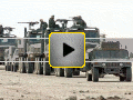
All the available map management features are in the Maps menu on the country home page. One of the features allows presidents to customize the way their country maps look. Presidents are able to show a smaller percentage of their roads and railroads, or a much higher density of roads, highways and railroads. They are able to move cities, factories, military bases etc.
It is also be possible to decide on the numbers of bases and military airports that are shown on the map. These numbers influence the number of cities that are being shown.
The pictures on the maps that show cities, factories etc. have a set of variations to choose from.
Moving objects on the map by an easy point and click method. You can also decide whether to show these items on the map or remove them.
Both the small map and the "zoom in" larger map can be modified using the same click and point method. The large map is four times bigger than the smaller map and on most screens will show without any scrolling.
It is also possible to repaint the maps on command and change the percentage of roads and railroads you want to see. It is also recommended to repaint the map when cities or factories or other objects have been moved.
Icons for individual items on the maps can be changed, choosing them out of a list of available icons. More Icons will be added to allow more choices.
Copyright ©2002-2011 w3creative.com
|
contact us